CROWLE & EPWORTH

Historic Background
During the prehistoric period there was a lot of activity in Crowle and the surrounding area. Multiple find spots are recorded to the north of the town, in the region of Rainsbutt Road. The landscape during this period was part of a river system and much of the evidence of activity recorded may have been on the edges of these channels. Flints from the Mesolithic, Neolithic and Bronze Age have been in recorded the survey area, indicating that hunting and woodland management was taking place locally. There is increased settlement evidence from the Iron Age and extensive evidence of Romano-British activity in Crowle parish . Roman agricultural and settlement enclosures are recorded in the immediate area surrounding the town centre, and find-spots are also frequently recorded, including coins, pottery and jewellery. Finds recorded in the town centre dating to between the 2nd and 4th century are suggestive of a probable small scale domestic settlement here during this period. Occupation of the town centre took place during the early medieval period, and evidence of activity dating to the 9th-10th century has been recorded. A religious structure was located in Crowle during this period indicated by the presence of the ‘Crowle Stone’, a fragment of a decorated Anglo-Saxon cross-shaft or monument which was reused by Norman masons during the construction of the church of St Oswald in the 12th century. This is supported by the Domesday survey of 1086, which recorded a church in the town. A manor was also recorded in the Domesday survey, as well as villagers, smallholders, meadows, woodland, fisheries and ploughlands. Crowle had a comparatively large local population at the time of the Domesday survey, probably concentrated around the church and to the west of Brunyee Road. In the 13th century, burgage plots (narrow property plots) began to be set out along the High Street and also fronting onto both High Street and the Market Place.


During the medieval period, Crowle’s economy was dominated by its landscape, the parish had an abundance of common land which was used for grazing and resources, a large fishing area as well as arable fields. In the post-medieval period, the Isle of Axholme was transformed and the profitable pastoral agricultural systems which had been in place for centuries were lost. This was brought about through large scale drainage schemes, instigated in 1626 following an agreement made between Charles I and Cornelius Vermuyden. These schemes transformed the landscape draining the common land, reducing commoners’ access to it and overhauling the nature of the local agrarian system. The landscape was further altered in the 19th century following the instigation of parliamentary enclosure and warping in the parish. This further divided the landscape and converted former common land into highly fertile arable farmland. In the modern period, Crowle has remained a small town. Population growth has been steady and residential development has taken place in the area immediately surrounding the town. In the later 20th and early 21st centuries, the town has become a dormitory town for the larger surrounding towns, its focus changing from agriculture to residential.
Character Summary
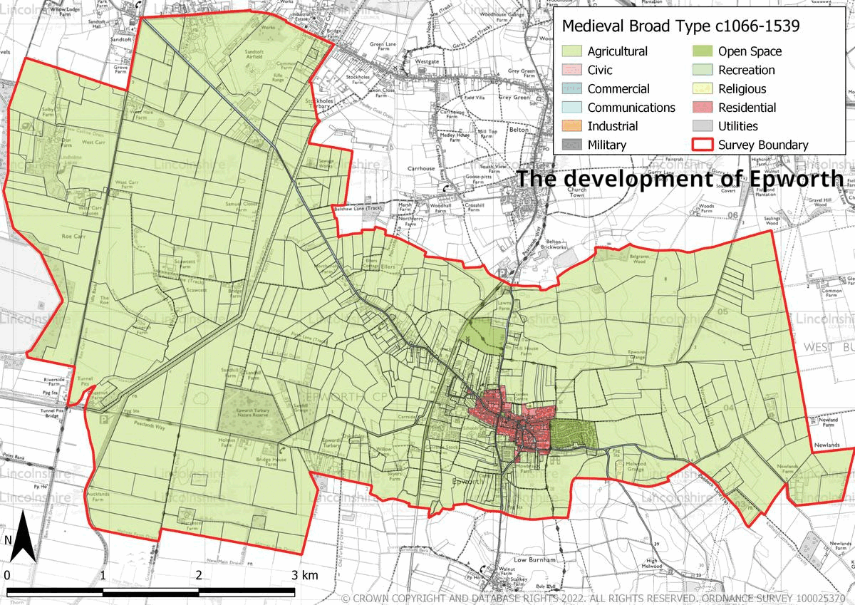
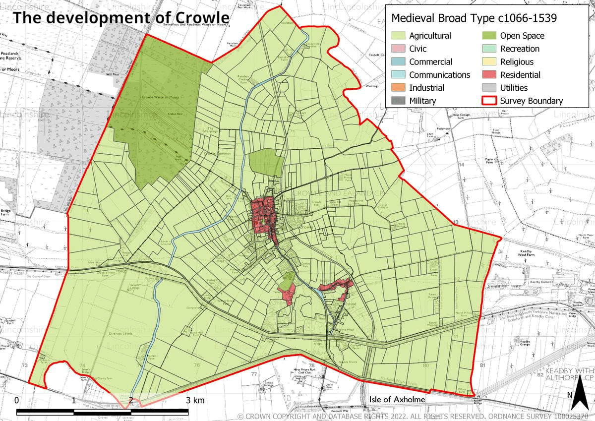
The character of Crowle is varied with structures and layouts from multiple periods recognisable across the parish. The town centre, seen in HUCA 1 reflects its use as a market centre, with terraced shops, public houses and a church. Brick is the dominant building material although some stone is used. Historically, this area was the centre of commercial activity and has been used as such for centuries; medieval burgage plots probably established at the same time as the Market Place can be seen facing onto the High Street, with some preservation of their pattern. Although the layout of HUCA 2 is likely to be medieval, the remaining development in the area is post-medieval and modern having been largely developed over the 19th and 20th centuries. The 20th century expansion of the town is captured in HUCA 3; houses are located along the main roads and in some purpose-built developments. The separate hamlet of Ealand is recorded in HUCA 4; this historic settlement has grown, predominantly over the 19th and 20th century, following the construction of new major communication links including the Stainforth Canal, a railway station and the A161. The character is a mixture of early 19th century farmsteads, Victorian detached and terraced housing interspersed with modern infilling of detached housing. An area of static caravans and lakes adjacent to Ealand are recorded in HUCA 5. The lakes, which are the remains of former clay quarry pits, have created a new area for recreation in the area. A large amount of the survey area (HUCA 6) comprises open countryside. Much of this is made up of arable fields, characterised by post-medieval and modern field patterns. An area of former moorland has also been converted into a modern nature reserve.
Download the Crowle EUS report using the button below.
Download the Crowle Historic Environment Records using the button below.
Download the Crowle HUCT Image Pack using the button below.
Download the Crowle HUCA Map Pack using the button below.
Epworth
Historic Background
Epworth during the prehistoric period was largely a low-lying and seasonally waterlogged or flooded environment except for an area of higher, drier land where the town was later to be established at least on a seasonal basis. Peat layers recorded from the survey area suggest that the area was part of a marsh environment during the late glacial period (12000-10000BC). Aerial photography and field walking in the area has highlighted a number of possible prehistoric sites, and scattered finds often of tools such as Axes, which are indicative of environmental management and forest clearance. Archaeological excavation on some sites across the area have revealed ditches and enclosures at the eastern and western limits of the survey area. Archaeological investigation of a site to the south of Carrside recovered pottery and charcoal dating to either the Iron Age or the Roman period (NLHER: MLS21349). There is a lot of evidence for Roman activity in the wider area of the Isle of Axholme, and within the survey area. Across the survey area, scattered Roman finds are recorded including coins and pottery. To the north of Epworth town centre there are also two probable settlement sites recorded, indicated by the large amount of pottery recovered in the vicinity. Epworth began to grow into the present-day town during the early medieval period, when it became the administrative centre of its own area. By the Domesday survey of 1086, the settlement had a local population, and an established agricultural system. The town became part of another administrative district in the later medieval period; however it did continue to grow in commercial importance demonstrated by its acquisition of a formal market charter in the 14th century. It was also during this period that the town was planned, the evidence of which is still visible in the present day road pattern. The agrarian systems continued to be developed over the medieval period and played a central role in the local economy of the town. This system of communal arable farming and communing endured into the 17th century, when a large part of it was curtailed by the introduction of large-scale drainage schemes in the Isle of Axholme, instigated by King Charles and Cornelius Vermuyden. This disrupted the agricultural organisation of the town and also resulted in lasting changes across the landscape.


In the early 19th century some areas of the parish were enclosed through a Parliamentary Act, although some parts of the area had been subject to private enclosure before this. This further disrupted the local agricultural make-up of the parish. In compensation for the loss of agricultural land and rights some local people were offered turbary and small holdings in exchange. These areas can be seen, although altered, in the present day. A great deal of hemp and flax was grown in the Isle of Axholme and in the 18th century, local cloth making factories were set up, contributing to the local economy. The town saw further large changes in the 18th and 19th centuries as older mud and stud buildings were replaced with brick and pantile structures, many of which make up the present day town. New civic and religious buildings were built during this period, coinciding with the rise of methodism. Wesleyanism was also established in the town by local man John Wesley, and as such Epworth has an incredibly important role in the founding of this branch of Methodism. Wesley’s childhood home is now a museum and statues of the preacher are also extant in the town. In the modern period, the town has grown, although not to a large degree. Its former trades have largely ceased and although there are small local traders and commerce, it has become a dormitory town for larger population centres such as Doncaster and Scunthorpe.
Character Summary
The character of Epworth is one of small scale brick built structures, which is a direct result of a fairly small local economy which has dominated in Epworth throughout its history. The town centre, which is represented in HUCA 1, reflects the 18th and 19th century redevelopment of the town and the founding of multiple local buildings of civic importance such as the Old Rectory, new Methodist churches, schools and the police station. This expansion continued on the main road out of the town, which is represented in HUCA 2 across Station Road and West End Road, where a number of farmsteads and 19th century properties were constructed. In the 20th century, this area, was infilled with modern residential development largely comprising detached housing and bungalows. In HUCA 3 larger residential expansion occurred in the town, on its east, west and south sides is recorded. This development comprised private and public residential development as well as schools for the growing population. The agricultural land which is pivotal to the history and economy of Epworth is characterised in HUCA 4. This has a well preserved and varied character, displaying field patterns from the medieval, post-medieval and modern periods, as well as evidence of the sweeping changes which followed the wider draining of the Isle of Axholme. The landscape of surviving ancient open strip fields and early enclosures surrounding the town centre of Epworth, together with its turbaries, is of national importance. North Lincolnshire Council seeks to protect this special character in its Local Plan (NLC, 2003).