GRANTHAM
Historic Background
There are extensive recorded finds and monuments from the Prehistoric period. Evidence of Palaeolithic axes, Mesolithic and Neolithic tools have been recorded across the survey area. There is increased archaeological evidence from the Bronze Age and cemeteries are seen to the north and south of the town. Settlement evidence is not seen prior to the Iron Age, although it is possible that there was occupation within the survey area. From the Iron Age extensive evidence of settlement is seen particularly to the south and east of the survey area.
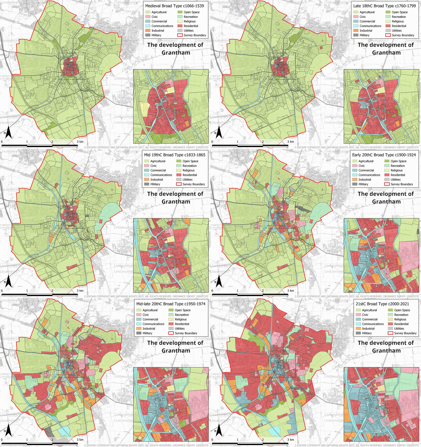
Archaeological and documentary evidence from the early medieval period demonstrate that the town was a populous settlement at this point. The Domesday Survey documented that Grantham belonged to Queen Edith before passing to William I after the conquest. It is recorded as having a hall, a church, over 100 burgesses as well as mills, agricultural land and meadow, and would have been a sizeable settlement at the time. St Wulfram’s Church was also noted in the Domesday Survey. The name ‘Grantham’ probably derives from this time with the root for the name possibly originating in Old English. In the early medieval and medieval periods, much of the town was planned and established, including the road pattern and the property boundaries, many of which have survived through to modern day. One important factor in Grantham’s success was the construction of a bridge, crossing the River Trent in Newark in 1168. This bridge caused traffic to be directed north along High Street and Watergate rather than Swinegate, resulting in increased development on the west side of the town.
Like many towns in the Midlands, Grantham’s wealth was, for a long period, due to the wool industry. To the west of Westgate, a Franciscan friary (HER: MLI30494) was established in 1290. This friary was in operation until the mid 16th century, at which point the land, as well as the friary, kitchen, malthouses, fields and orchards were given to court gentlemen following the religious reformation.


In the post-medieval period, wool was displaced as the leading industry in Grantham’s economy. Coaching, grain production, malting and machine manufactory became the main industries in the town. Several new coaching inns, public houses and service industries were established as it grew in importance as a waypoint on the Great North Road. This importance was further enhanced by the introduction of the Turnpike roads in the 18th century which created more efficient connections in all directions. In 1792, Grantham was connected to the canal network; this reduced the reliance on the road network to transport goods and the turnpike trusts were closed by the end of the 19th century as a result. This was further exacerbated by the introduction of the railway in 1850, which in-turn also reduced the reliance on the canal network. Grantham became an industrial town in the 19th century; consequently large scale development grew outside of the medieval boundaries, as new streets, schools, public houses and churches were built close to the canal and railway. These residential developments and amenities were established for the railway employees and also for those working in the machinery factories which had been built in the south of town.
In the modern period the town has become a commercial and civic centre. New residential suburbs have largely been moved to the outside of the town centre, and the properties which originally were houses have been converted into shops. Prior to 1961, traffic travelling north-south would pass through the town causing severe congestion as numbers on the roads increased. In 1961 the A1 was constructed allowing traffic to by-pass the town centre. Within the town centre there has been much re-development; a large amount of this has taken place behind historic street frontages, such as The George and Isaac Newton shopping centres. Some redevelopment has taken place on the street fronts such as the post-war redevelopment of Watergate and High Street which has removed some of the historic fabric of the town.
Character Summary
HUCA 1 is the medieval core of the town and has been characterised separately for the purposes of assisting the HAZ in providing a baseline for that project. The character area is predominantly commercial with most of the streets comprising rows of shops. There are a small number of residential streets in the character area; however most of the residential areas in Grantham have moved outside of the town centre. The buildings extant in the street-scape are a mix of ages, mostly from the 17th –19th century; however some earlier properties survive. The older properties in the town centre are usually constructed in Ancaster Limestone; however, brick is the main material in the character area with the post-medieval and modern development constructed using this material. HUCA 2 records the late 18th and 19th century expansion of the town, largely through industrial and residential development. The dominant material here is red brick, some of which would have been manufactured locally and the dominant style is terraced streets. In the modern period, some of the older development has been replaced by new industry as well as some flats. HUCA 3 and 4 represent the 20th century residential expansion of the town. The earlier development, which comprises more mixed houses as well as council led developments is recorded in HUCA 3. The later 20th and early 21st century development is recorded in HUCA 4. Schools and local amenities were developed as part of both of these HUCAs. HUCA 5 represents the agricultural land on the edge of Grantham and open parkland. This largely reflects modern field patterns and some buildings such as farmsteads and light industry are extant.

