SLEAFORD
Historic Background
There is evidence for human activity in the parish of Sleaford from the Mesolithic period. However, it is not until the Iron Age that there is archaeological evidence for long-term settlement. There were at least two areas of Iron Age settlement, the most important being at Old Sleaford. This was probably an important settlement in the Corieltauvian territory with a possible mint located there. The Old Sleaford Iron Age settlement continued through to the Roman period, although it had lost importance. A Roman road would have continued north from where Mareham Lane turned west and met the River Slea, where it possibly crossed a ford and continued northwards. There is further evidence of Roman activity in other parts of the area, with farmsteads, burials and archaeological finds being recorded.

Church of St Denys, Sleaford


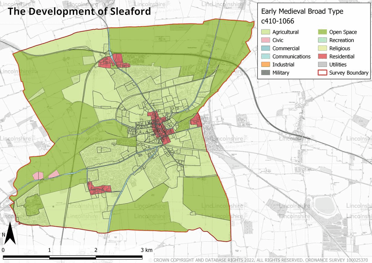
In the early medieval period there were four distinct settlements in Sleaford: Old Sleaford, New Sleaford, Quarrington and Holdingham. Throughout the medieval period Sleaford, or New Sleaford, developed into the primary settlement of the area, although Quarrington was the manorial seat for the southern part of the survey area, with its own parish church. Sleaford became an important market town under the lordship of the bishops of Lincoln. It is during this time, in the 12th century under Bishop Alexander, that Westgate and Sleaford Castle were formed. In 1154 King Henry II granted a market charter for Sleaford to the bishop of Lincoln, although a market may have been in existence before this. Sleaford’s economy at this time was characterised by the abundance of mills on the River Slea, the existence of burgesses and a regionally important market. The area’s landscape consisted of arable open fields to the north and south of Sleaford bordered by areas of fenland—mainly by the river— and heathland.
This changed at the end of the 18th century, when the land was enclosed via an Act of Parliament. The land enclosure was accompanied by drainage of the fenland and its agricultural use, as well as that of the heathland. During this period the Navigation Canal was also constructed, which made it possible to navigate from Sleaford to the River Witham. This led to increased trade and industrial activity in the town, with industry concentrated around Carre Street and the canal head. The use of the canal began to decline with the arrival of the railway in Sleaford in the mid-19th century. Industrial activity began to gravitate towards the railway station instead and in the beginning of the 20th century, the nationally significant Bass Maltings were constructed on the southern side of the railway tracks. The 19th century saw the population more than double; however, this was not accompanied by an increased urban expansion. There was some residential expansion in Sleaford, but it was not until the late 20th century that the urban area grew significantly. It was also at this time, and in the 21st century, that the town’s industry began to centre around the industrial estate to its north
Cogglesford Watermill, Sleaford

Cogglesford Watermill, Sleaford


The Handley Monument, Sleaford
Character Summary
There are six identifiable areas of distinct character within the survey area, these are called Historic Urban Character Areas or HUCAs.
HUCA 1 constitutes the historic medieval core. The area has a medieval street pattern with post-medieval and modern buildings throughout. The character of the area is primarily commercial, with residential buildings also present.
HUCA 2 represents the 19th century and early 20th century residential and industrial expansion in the town. The character of the area is mixed, with modern developments alongside 19th century housing and industrial buildings.
HUCA 3 is formed by large 20th and 21st century residential developments, with a mixture of terraced, semi-detached and detached housing. HUCA 4 consists solely of the large industrial estate to the north of Sleaford, off East Road, which has been developed from the late 20th century. HUCA 5 traces the medieval outline of the settlement of Quarrington, with its parish Church of St Botolph. This is the only remaining medieval building, the area is now mainly characterised by 20th and 21st century housing. Despite the area being composed mainly of modern housing it is still centred around the village’s main road, Town Road. HUCA 6 represents the surrounding agricultural land, which is divided between north and south by the River Slea. The parcels of land have hedgerows for boundaries and post-medieval farmsteads with modern agricultural units can be found throughout the area.